Start & Finish: Sant’Angelo a Palmobara Sanctury (549 m) / Sat Nav: 40.999688, 14.478808 / Distance: 0.6 km/ Ascent: 125m / Typical Duration: 30 mins – 1 hour / Category: Moderate difficulty
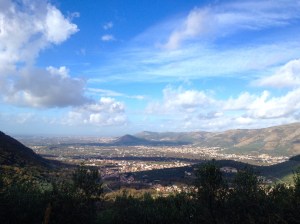
This is one of my favourite places to take people who are new to Campania because it has stunning views and just a hint of adventure! The best way to start the day is with a delicious ‘cafe e corneto’ at Bar Centrale in San Felice a Cancello. You then wind out of the village up through glorious chestnut groves to the Sant’Angelo a Palombara Sanctury, which is perched on the edge of a rocky outcrop and has a stunning view of the Valle de Suessola. Next, there’s a short, steep walk through the forest and up to the skyline proper. Here you will feel like you’re on top of the world with a dramatic panorama taking in the Picentini ranges, Vesuvius, downtown Naples, Capri, Caserta and the Taburno mountains. If you’d like a longer day out, this walk can be extended (details coming soon) and it links well to other places in the area such as Vanvitelli’s aqueduct in the Valle di Maddeloni and the medieval village of Sant’ Agata dei Goti.


Background
San Felice a Cancello is a large village on the northwest fringe of the Partenio National Park, between Naples and Caserta. It is nestled at the far end of the Valle di Suessola, with steep hills on all sides (once used as an encampment and observatory site by American troops during WWII). The area is known for the production of olives and chestnuts which thrive on the sheltered slopes and also for local historic crafts such as making baskets. The village has Lombard origins and signs of its colourful history abound on the landscape including fortifications such as the Castello di San Felice (300m) and the Castello di Arienzo which you see on on Monte Argentario (430m) as you drive back to San Felice after the walk.
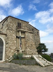
The walk starts at an ancient sanctuary situated on a rocky spur on the side of Mt. Sant’Angelo a Palombara. The earliest mention of a religious site here dates back to 970 when it was just two caves. Over the years it developed into an Abbey with monks in residence and was closely linked to Sant’ Agata dei Goti. Today it has two naves, with wooden statues representing St. Michael and Madonna della Libera and you can still see ancient frescos representing Saint Catherine of Alexandria. Unfortunately it is only open on special ‘festa’ days when a ‘soulful bell tolls’ calling the faithful to walk along the river valley then up steep steps, acknowledging the 14 stations of the cross on the way. You can see the steps and one or two ‘stations’ from the parking area. A final holy reminder is the Croce Monte Sant’Angelo Palombara, a large metal cross which you find just as you emerge from the forest towards the pinnacle of the walk. It’s old and leans to one side and I always find it a moving place to pause for a moment before the summit.
Directions by Car
This is definitely more of a driving adventure. It’s not that hard but it takes you through the narrow back streets of San Felice a Cancello and out on to the hill. There are sharp, narrow bends and you need to be careful but bold on the gas! Do it once and you’ll wonder why you worried the first time, I promise.
Follow the SS162 to the centre of San Felice a Cancello and on to Via Napoli heading East. It becomes via Roma and quickly narrows with a pretty avenue of trees on both sides. Go slowly along here and turn right on to Via Elevata**. Continue on this road without turning until it narrows and becomes Via Cave and then Via Talanico. After a short while, look for steps and a square above you on your right and go right on to Via Marcantonio Di Rosa (the turning is opposite a building with a fantastic bell tower). Continue on this road out of the village and on to the hill, rising steeply and winding around the bends. After a couple of kms, you will notice the road widen with a white limestone hedge with cactuses on top to your left. There are three roads ahead of you. The road to the sanctuary is on the right. However, if you have time, park up and walk along the road to the left a few hundred yards – there’s a wonderful view of the forests and the rest of the Partenio range. Do not drive along this road (it gets very steep with no barriers and it is extremely difficult to turn!). Do not take the little downhill road straight ahead – it goes to houses down in the valley.
Take the road to the right – it looksrough to start but then goes around a right hand bend and there is new tarmac on one side all the way to the top. The cultivated Chestnut groves turn to pine forest beside the road. After 2-3 kms you will reach a large parking area and the sanctuary on your right.
Driving Notes
On the way home, once you reach the T junction right down in San Felice at end of Via Elevata, you have to follow the one way system back to the SS162. So go right back on Via Roma, left on Via Papa Giovanni XXIII, left on Via I Maggio, right on Via Laurenza and then you will reach the SS162.
**If you go for coffee at Bar Centrale before the walk – then ignore the left turn from Via Roma on to Via Elevata and drive a short way further until you reach Via Papa Giovanni XXIII on the left with a square and parking. Bar Centrale is a small yellow building opposite this turn (also with a small square outside). It’s run by a family and when we there 5 brothers, sisters and cousins were serving – you can imagine the banter! It was a cold winters day and I could practically stand my spoon in my hot chocolate – a perfect bolster before our walk. Afterwards, you will need to carry on down Via Papa Giovanni XXIII around the one way system (left on Via I Maggio, right on Via Laurenza, left on the main SS162 and first right on to Via Crocella Santa, left back up to via Roma to get back to Via Elevata). It sounds complicated but it isn’t and only takes 2 mins!
Walk Description – Short route
Stand with your back to the doors of the Sanctuary so Jesus is behind you! Go left, as if you are going to walk down the road you just drove up. Just as you leave the parking area, look for a stony track rising up at an angle to the road on the right. It has a wooden criss-cross fence and leads up a short hill. After about 200m you will come to a little woodman’s hut – if you don’t see this right after you begin, you are on the wrong track!
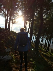
Go right around the sharp bend by the hut and follow the track up. You will be in a dark pine forest, walking along a gently rising track with limestone terraces above and below. As the path starts to loose definition, stop and look up to your left and get your bearings. You are trying to walk right to the top of the hill you can see. Carry on forwards but also starting to climb up the terraces slightly to your left. Continue forwards and up and sideways for a short while until you reach the edge of the tree line. You will be on a very steep exposed hill with a rocky path rising ahead. You can scramble up this (with the trees on your left and scrub on your right) all the way to the cross at the top.
Alternatively scramble for about 50m until you see a better formed terrace track leading left back into the forest. I prefer this way. Follow the terraces back and forth going across and up the hill. There is a big tree down across one. Each zig-zag gradually gets shorter as you climb the hill and then you are forced just to pick your way up through the trees to the top and out of the tree line again where you will see the cross. From here it is wise to keep dogs and children very close. Go past the cross and up onto a plateaux. In the middle you will see another rise – go up and you will see a big limestone sink hole in the top.
Explore the plateaux and enjoy the magnificent views before heading down. Return slowly back and forth along the terraces until you come to the main path up. To be honest, I seem to go back a slightly different way each time but always meet the lower path quite easily in the end.
Walk Description – Long route
Coming soon..
Map
Timings
Short route: Give yourself 2 hours minimum for this walk. You will be charmed by the views across the Valle di Suessola as you drive up (it’s hard not to stop and take photos) then once you reach the sanctuary you’ll spend a good while enjoying the vista before you start. Once you set off, the walk to the top will take about 20-30 mins for a reasonably fit adult. With kids/dogs/friends give yourself longer as there’s so much to nature explore in the forest, plus a very steep final section. Kids under 3 will need to be carried.
Long route:
Coming soon..
When to go
It’s great all year but to make the most of the views you need a clear, sunny day. There are gorgeous wildflowers in Spring and the colours of the Chestnut groves in Autumn are stunning too. Do not go if rain or wind are forecast – it’s fairly high up and would not be safe.
Dogs
The forest is a great place for dogs, however it is very steep in sections so you may want to keep them close until you are sure of the landscape. Definitely keep them on a lead at the top of the hill near the sink hole.
Amenities
There are no amenities after you leave San Felice a Cancello – take everything you need. We often walk up to the top of the mountain and back, then have a picnic on the steps of the sanctuary before heading home.
Walks nearby
Sasso - coming soon
Arienzo - coming soon
Useful links
Local attractions
Aqueduct of Vanvitelli at Maddaloni
