Start & Finish: Mont Petrino / Sat Nav – parking & start of walk: Parking 1 – 41.12773, 13.91276 OR Parking 2 – 41.13371, 13.89936 / Start elevation: 287m /Max elevation: 389m / Gain: 85m / Total distance: 0.8 km one way / Typical Duration: 30 mins one way / Category: Moderate (steep climb)
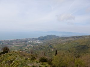
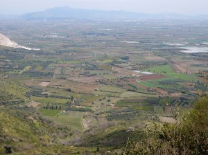
Last spring I hiked up Mont Petrino and ended up sitting among the ruins of Forte Rocco Dragonis for over an hour photographing a pair of striking swallowtail butterflies. They were mesmerising as they danced around each other on the warm wind, swooping down to feed on the flowers. When you come out of the woods to the end of the path, you pick your way through to the large medieval structure, right to the edge of the cliff and it was here that I found them. Beneath me was the wide Campania-Felix plain, neatly divided into thousands of farm plots in every shade of green and pink from the fruit orchards. Had it been a clear day I’d have seen all the way to Vesuvius and the islands in the bay. Though it’s a steep climb up, the path is good and it’s well worth the effort. It’s great for dogs and kids but you must keep both very close when you reach the castle as it’s high and the ruins are not secured.
Map below, more details coming soon...


Map
Please read the note on parking!
